Content
Climatology of Mesoscale Airmasses with High-Theta-E
A component of a larger NSF-funded project led by Dr. Jason Keeler (Central Michigan University), this work involves the development of a climatology of Mesoscale Airmasses with High theta-E (MAHTEs). MAHTEs are unique because, despite cooler temperatures than the warm airmass on the opposite of the parent airmass boundary, CAPE is higher due to higher moisture content. Given their relatively small size and importance for deep convection forecasting, MAHTEs are an important forecast challenge. This research will utilize ASOS/AWOS data along with regional mesonets to characterize the spatiotemporal distribution of MAHTEs.
Project lead: Charles Kropiewnicki
Assessing Deep Convection Initiation in a Mountain-Valley System Using Unoccupied Aircraft System Observations
On 15 July 2018, UAS collected vertical profiles at fixed locations across the San Luis Valley during IOP1 of the LAPSE-RATE field campaign. (SSRG participation in LAPSE-RATE was supported by the NSF-funded CLOUD-MAP project.) The UAS observations revealed that the non-irrigated region had higher heat content and lower moisture content than the irrigated region, and that the differences often extended several hundred meters above the surface. These thermodynamic differences resulted in traditional DCI metrics, calculated from UAS-modified soundings, implying that the non-irrigated region was more favorable for DCI. DCI occurred first over the non-irrigated region, and all instances of DCI within the SLV occurred within an hour of the passage of a low-level convergence zone.
Project lead: Alex Erwin and Ben Moll
An Analysis of the Impact of Urban Heat Islands on Convection Initiation
This research focuses on the impact that Urban Heat Islands (UHIs) have on convection initiation. Using a database developed from the Thunderstorm Observation by Radar (ThOR) algorithm, I will be analyzing the spatial distribution of thunderstorm initiation points in the central United States between 2005 and 2015. Previous research has usually focused on precipitation anomalies or convective impacts of one city, but this wide ranging database will allow for an analysis of many UHIs at once. The variety of UHIs will also shed light on which factors may make a UHI more conducive to initiating thunderstorms.
Project lead: Ryan Martz
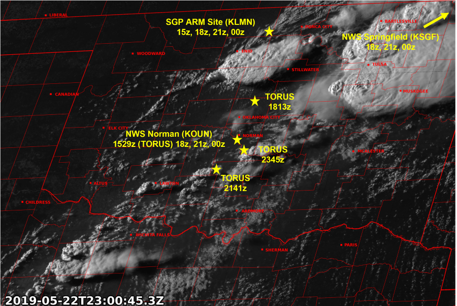
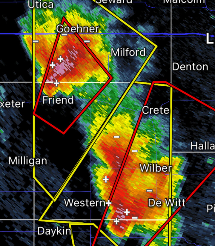
An Empirical Examination of the Environmental Factors That Regulated Thunderstorm Longevity on 22 May 2019 in Oklahoma
The goal of this work is to understand the environmental characteristics that resulted in the observed convective evolution during a case from the 2019 TORUS field campaign, particularly why more supercells were unable to develop from the deep convection that did form in what was a seemingly favorable environment (characterized by strong instability and a favorable vertical shear profile, leading to high Supercell Composite and Significant Tornado Parameter values). This favorable environment for intense supercells and tornadoes was in place across a large portion of Oklahoma on 22 May 2019, resulting in the issuance of a PDS Tornado Watch. While deep convection initiated in multiple locations throughout the watch polygon, the majority of the storms that formed were relatively short-lived and non-tornadic. This environment was well-sampled, as there were several radiosondes launched by TORUS , as well as by the NWS offices in Norman, OK and Springfield, MO, and by the ARM Southern Great Plains research facility in Billings, OK. Using the Thunderstorm Observation by Radar (ThOR; Houston et al. 2015) algorithm to track the deep convection that initiated across the domain, the vertical profiles from the inflow region of many of the convective cells that formed can be examined using both the observed soundings and the soundings generated by the 13-km Rapid Refresh (RAP) modeling system’s hourly analysis. By focusing on sounding-derived parameters which have been shown to be important to convective initiation and storm longevity (lift, inhibition, buoyancy, and dilution parameters), it is possible to gain insight into which of these characteristics helped best distinguish the near-storm environments that fostered intense convective development from those that did not.
Project lead: Kyle Pittman

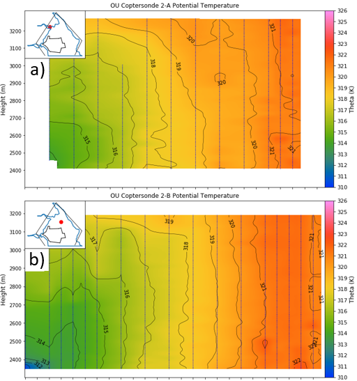
A UAS-Centered Investigation of Vorticity Characteristics and Cold Pool Structure Across Forward and Left-Flank Boundaries in Supercells
Supercell internal boundaries are the locus of tornadogenesis; thus, understanding the characteristics of these boundaries, particularly in terms of vorticity, is important for identifying the role they play in tornado formation. Insight into the overall characteristics of internal boundaries and their possible role in tornadogenesis have been driven by studies reliant on numerical modeling-based experiments. Observational studies often neglect above-surface conditions or, when these observations are made, lack the spatial resolution to resolve boundary characteristics. During TORUS (Targeted Observation by Radars and UAS of Supercells) 2019 and TORUS-LItE (TORUS Left-flank Intensive Experiment) 2023, uncrewed aircraft systems (UAS) and mobile mesonets collected in situ kinematic and thermodynamic observations across left and forward flank boundaries. Three TORUS and TORUS-LItE cases are analyzed herein with the goal of updating understanding of supercell internal boundaries. This analysis reveals that the strongest near-surface vertical vorticity is typically collocated with enhanced streamwise vorticity, baroclinic generation, and gradients in vertical motion and equivalent potential temperature. Horizontal gradients in vertical motion distributed over scales of several hundreds of meters are present in all three cases and made appreciable contributions to horizontal vorticity. Analysis of the 26 May 2023 case reveals a likely streamwise vorticity current (SVC) embedded in the head of a density current-like feature. Comparable structures are observed in the left flank boundaries of the 11 June 2019 case, but with differences in cold pool shape and pressure perturbations.
Project lead: Mark De Bruin
Assessing the Impact of Assimilating Observations from the TORUS Campaign on Forecasts of Severe Deep Convection
Due to the resolution of the observing system in the United States, mesoscale heterogeneities that influence severe deep convection may not be accurately depicted in the initial conditions of storm-scale numerical weather prediction. Field campaigns recording observations in the far-field, near-storm, and in-storm environments present an opportunity to test whether assimilating such observations can improve the representation of mesoscale phenomena in initial conditions. This study aims to address this issue by assimilating targeted observations near supercells from the Targeted Observations by Radar and UAS of Supercells (TORUS) campaign into a storm-scale model using a cycled EnKF framework, including data from mobile mesonets, UAS, and radiosondes. Data-denial experiments will be performed on the data across three sections of the atmosphere (surface, planetary boundary layer, and the free atmosphere) in addition to isolating UAS data to determine its impact. This work extends a previous study conducted to assimilate data from the 8 June 2019 TORUS IOP to include two additional TORUS cases from 2019, a case from 2022, and a case from 2023. These four cases will be examined due to data availability, specific features of such cases that were hypothesized to reveal the effectiveness of assimilating observations, and due to the fact that case study analyses have been or are being performed on each case. This study aims to both determine the impact of assimilating the TORUS observing system on convective representation in the storm-scale model and determine whether a specific atmospheric region of the observing system was most important in providing meaningful forecast improvements.
Project lead: Robert Szot
Using Cloud-to-Ground Lightning to Predict Tornadogenesis in Supercell Mergers
Supercell mergers are highly variable and dangerous events that can lead to a wide variety of outcomes, ranging from storm collapse to violent tornado production. There are many factors that can influence these events, including the updraft strength, environmental vorticity, and low-level shear, to name a few. Some of these factors- namely the updraft strength- are often manifested in cloud-to-ground lightning patterns and behavior. This research project aims to identify connections between these lightning properties and tornadogenesis in supercell merger events. This will provide forecasters with a new metric to predict these potentially destructive events and will expand the body of research on supercell mergers, as well as their weakly-understood lightning properties.
Project lead: Amy Conner
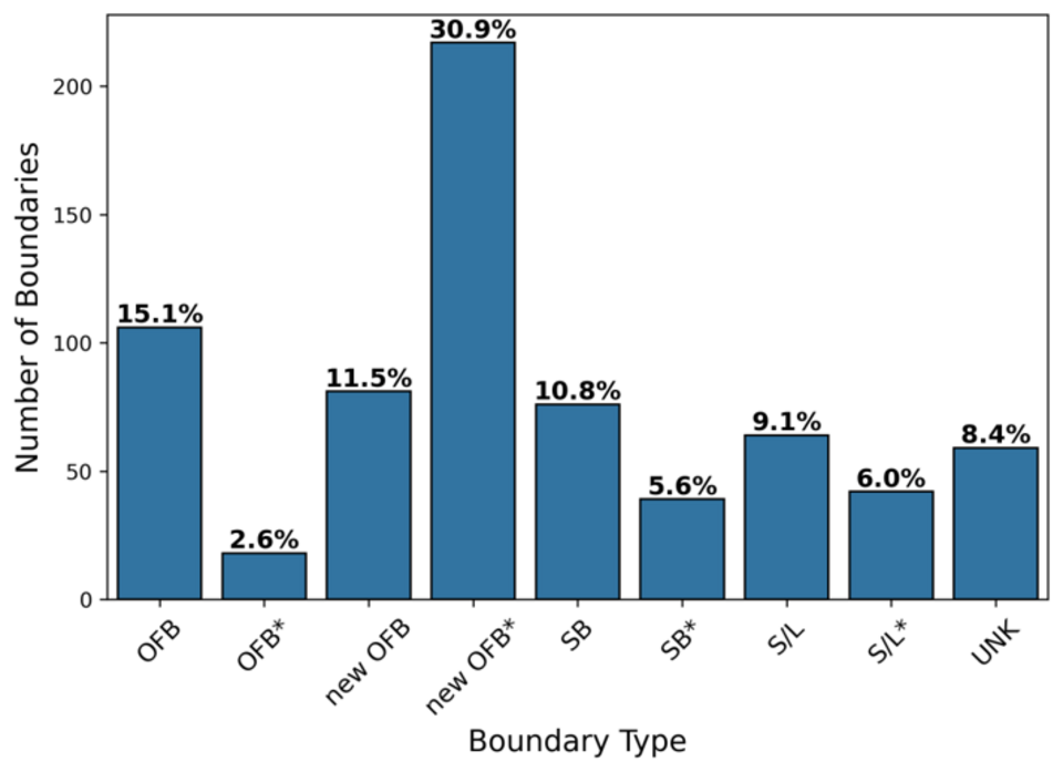
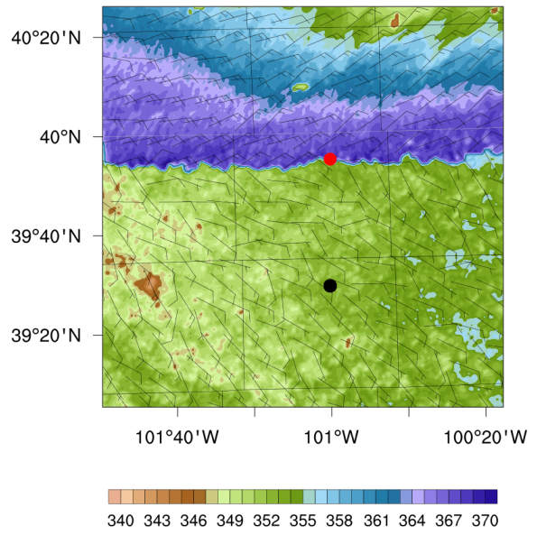
Advancing Understanding of Mesoscale Airmasses with High Theta-E through Airmass Boundary Classification
A Mesoscale Airmass with High Theta-E (MAHTE) is a narrow region on the cool side of an airmass boundary that possesses higher equivalent potential temperature (θe) than the warm side. MAHTEs are characteristic of higher CAPE, lower LCLs, and often higher 0-6 km bulk wind differential, making them potentially more favorable for severe convection and tornadoes. Previous work has cultivated a climatology of MAHTEs, however the type of boundary along which a MAHTE forms has not been formally analyzed. Thus, this work will analyze a subset of the climatology to classify the parent boundaries as synoptic, outflow, or lake/sea breeze.
Project lead: Anna James

An Examination of Methods for Calculating CIN Depth and Their Ability to Distinguish Thunderstorm Environments
This project, funded by UCARE, uses a dataset containing 62846 deep convection initiation points within the central United States from November 2008 through December 2015 and environmental profiles for each initiation point and associated null point (where initiation did not occur) from the Rapid Update Cycle (RUC) and Rapid Refresh (RAP) numerical weather prediction model analyses, to evaluate 10 parameters related to inhibition strength and depth to test how well inhibition depth can discriminate between deep convection initiation and non-deep convection initiation environments. The results show that inhibition depth can be used to discriminate between such environments, with the best performing methods being a calculation of mixed-layer convective inhibition depth from the parcel origin to free convection height
Project lead: Kylee Matousek
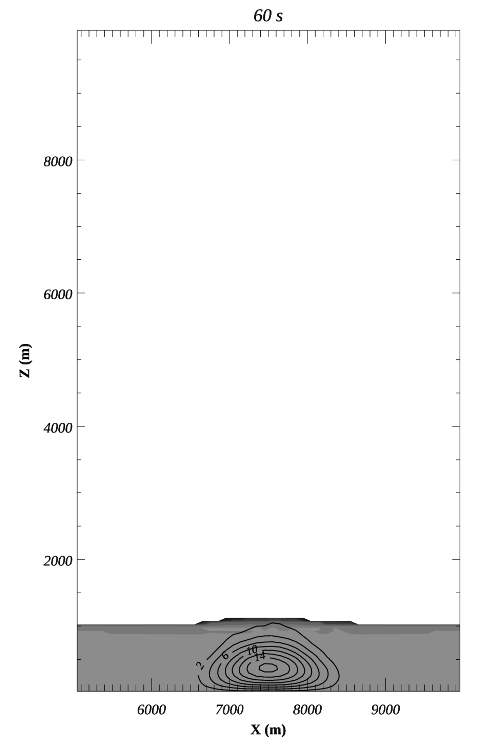
The Impact of CIN Depth on Simulated Deep Convection Initiation
Idealized numerical experiments are conducted to evaluate the sensitivity of DCI to CIN layer depth when controlling for CIN. A generic non-thermodynamic impulsive initiation mechanism is imposed below the LCL with free parameters allowing for tuning of size and strength but constrained to produce a controllable value of vertical motion at the LCL. Experiments reveal a systematic decrease in the likelihood of DCI as CIN layer depth is increased for a given CIN. The physically consistent and dynamically constrained (not prescribed) decay of non-thermodynamic forcing with time is found to be critical for explaining the sensitivity, but is manifested as clouds at the LFC that are too small to support DCI when CIN layer depth is too large. A modified parameter that accounts for both CIN and CIN depth is proposed.
Project lead: Adam Houston

Observing System Simulation Experiments to Investigate Impacts of UAS on Forecasts: Horizontal Transects
This work is part of a collaborative effort between the Severe Storms Research Group, the NOAA Global Systems Laboratory, and the Cooperative Institute for Research in Environmental Sciences. In this component of the project, observing system simulation experiments (OSSEs) are conducted to evaluate the impact of simulated UAS, distributed across the entire contiguous US and executing long horizontal transects within the planetary boundary layer, on the accuracy of a convection-allowing numerical weather prediction model. The sensitivity of this impact on the density of the UAS network and on a network with and without meteorological limitations on UAS flight (namely, icing) are also examined.
Project lead: Adam Houston

Observing System Simulation Experiments to Investigate Impacts of UAS on Forecasts: Radiosonde Replacement
This project is part of a collaborative effort between SSRG, NOAA's Global Systems Laboratory, and the Coorporative Institue for Research in Environmental Sciences. Uncrewed aircraft systems (UAS) are a promising horizon for atmospheric sampling and could fill existing data gaps in the observational network. Before pursuing a nationwide deployment of UAS, it is important to quantify the impact of a future network on model forecast accuracy and compare the relative strengths of various configurations of UAS. In this component of the project, observing system simulation experiments (OSSEs) are conducted to evaluate the impact of simulated UAS, distributed across the CONUS and performing vertical profiles of the whole troposphere, on forecasts using the High-Resolution Rapid Refresh (HRRR) convective allowing model (CAM). Data-denial experiments are performed replacing the existing radiosonde network with a gridded network of UAS to quantify the maximum theoretical benefit of UAS performing deep-layer profiles. The sensitivity of this impact from various sampling frequencies will be examined along with an experiment set comparing profiles to the tropopause (15km), mid-levels (9km), and planetary boundary layer (2km). An additional experiment set will examine the impact of placing meteorological limitations on UAS due to high winds and icing.
Project lead: Alex Swan
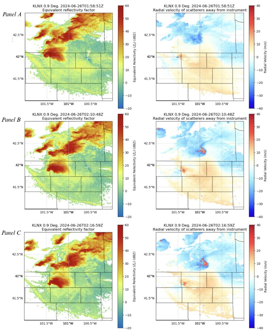
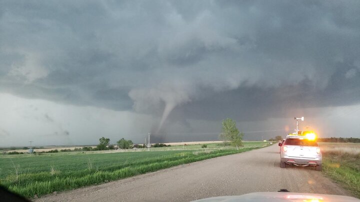
Case Study of 25 June 2024 “Whitman, NE” tornadic supercell
Funded through the University of Nebraska-Lincoln’s UCARE program, this research analyzes a synoptically unfavored tornadic supercell that produced an EF-3 tornado with a 57-minute track. Peer review of the event identified the potential presence of a Mesoscale Airmass with High Theta-e (MAHTE), which may have contributed to the storm’s rapid intensification. Building on this observation, this research investigates whether a MAHTE was the primary contributor to the tornadic supercell’s evolution. Mesonet observations from Whitman, Nebraska, in combination with Level II NEXRAD data and upper air observations from the North Platte radar site, are used to combine localized surface measurements with high-resolution radar imagery to identify mesoscale features. By characterizing the airmasses present during the event through analysis of Convective Available Potential Energy (CAPE), Lifted Condensation Levels (LCLs), 0-1 km Storm-Relative Helicity, low-level wind shear, and 0-6 km bulk wind differential, the research aims to determine whether a MAHTE was present and if it locally modified the environment to become more favorable for tornadogenesis.
Project lead: Josie Pettis